Property Survey
Professional measurement and drawing used to compare a property's physical boundaries and improvements with its recorded description.
A property survey is a professional measurement and drawing used to compare a parcel’s physical boundaries, improvements, and visible site conditions with its recorded description.
The scope and name of the survey product vary by location and transaction. A boundary survey, mortgage-location survey, improvement-location certificate, and ALTA/NSPS land title survey do not necessarily provide the same work or assurances.
Why It Matters
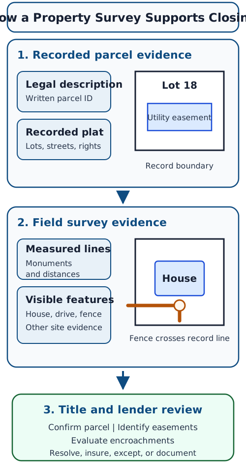
A street address tells people where a home is located, but it does not establish the precise land being transferred or pledged. A legal description identifies the parcel in documents, while a survey can show how record information relates to monuments, measured lines, fences, buildings, driveways, and other visible improvements.
That comparison can reveal an encroachment, a possible boundary dispute, or an improvement inside a recorded easement. These findings can affect the lender’s collateral review and the title insurer’s requirements or exceptions.
A survey is not an appraisal. It does not determine market value, inspect building systems, or promise that no ownership dispute exists. Its value depends on the surveyor’s scope, the evidence available, and the standards governing the work.
Where It Appears in the Borrower Process
A survey may be ordered during purchase due diligence, title review, construction lending, or a refinance. Whether one is required depends on the property, lender, title insurer, state practice, prior survey, and issues already visible in the file.
The borrower may see a survey fee on the Loan Estimate or Closing Disclosure when survey work is part of the transaction. Before relying on an older survey, the borrower should ask whether the lender and title company will accept it and whether later fences, additions, pools, sheds, or easements make it outdated.
How the Evidence Fits Together
The closing team compares record evidence with field observations rather than treating one document as the complete answer.
What to Review
| Survey item | Borrower-facing question |
|---|---|
| Certification and date | Who prepared the survey, for whom, and when? |
| Boundary lines and monuments | What measured evidence supports the parcel lines? |
| Buildings and improvements | Are the house, garage, fences, or other improvements shown? |
| Easements and rights-of-way | Do recorded rights overlap a planned use or improvement? |
| Encroachments | Does an improvement cross a line or occupy a burdened area? |
| Legal description | Does the survey reference the same parcel description used for closing? |
A borrower should not move a fence, concede a boundary, or sign an agreement solely from a quick reading of the drawing. The surveyor can explain the survey work; the title professional or attorney responsible for the closing can explain how a finding affects title and the transaction.
Practical Example
A buyer orders a survey for a detached home. The drawing shows the deed’s lot lines, the house, a utility easement along the rear boundary, and a neighbor’s fence extending across one corner. The title company reviews whether the fence condition must be resolved, insured over, or listed as an exception. The appraiser may consider any effect on use or marketability, but the appraisal does not replace the survey.
How It Differs From Nearby Terms
A plat map is a recorded map that may define lots, streets, and easements for a subdivision. A property survey applies measurements and field evidence to a specific parcel under a defined scope.
A legal description is the written identifier used in deeds, mortgages, and title records. A survey may reproduce or reference it, but the drawing and the description are not interchangeable.
An appraisal develops an opinion of value and reports relevant property characteristics. A survey focuses on location, boundaries, and specified site evidence.
A title search examines public records for ownership and claims. A survey can reveal physical facts that may not be apparent from the record search alone.
Related Terms
Knowledge Check
- Is a property survey the same as an appraisal? No. A survey focuses on boundaries and improvement locations; an appraisal focuses on value.
- Why can an older survey be insufficient for a current closing? Later improvements, fences, easements, or other site changes may make it incomplete or unacceptable.
- What does the closing team compare when reviewing a survey? It compares recorded parcel evidence with measured lines and physical site conditions.